Difference between revisions of "Peat depths in Scotland"
Jump to navigation
Jump to search
(Created page with "==Objective== This subproject evaluates the performance of Tessera representation maps in above-ground biomass (AGBM) estimation in Finnish forests. Accurate AGBM estimation...") |
|||
| (One intermediate revision by the same user not shown) | |||
| Line 1: | Line 1: | ||
==Objective== | ==Objective== | ||
| − | This subproject | + | This subproject aims to assess how well the representation maps produced by Tessera perform in estimating peat depth. Peat depth provides insight into long-term below-ground carbon storage, making accurate estimation valuable for carbon accounting and ecological monitoring. |
| Line 7: | Line 7: | ||
==Dataset== | ==Dataset== | ||
| − | The | + | The open [https://www.nature.scot/climate-change/nature-based-solutions/nature-based-solutions-practice/peatland-action/peatland-action-data-research-and-monitoring/peatland-action Peatland ACTION dataset] from Scotland consists of 160667 peat depth measurements (138363 measurements from year 2017 onwards). |
| − | |||
<div style="text-align: center;"> | <div style="text-align: center;"> | ||
<gallery widths="250" heights="250"> | <gallery widths="250" heights="250"> | ||
| − | File: | + | File:Peat_depth_locations.png|Peat depth measurement locations |
| − | File: | + | File:Peat_depth_distribution.png| Distribution of peat depths |
</gallery> | </gallery> | ||
</div> | </div> | ||
Latest revision as of 19:49, 26 May 2025
Objective
This subproject aims to assess how well the representation maps produced by Tessera perform in estimating peat depth. Peat depth provides insight into long-term below-ground carbon storage, making accurate estimation valuable for carbon accounting and ecological monitoring.
Dataset
The open Peatland ACTION dataset from Scotland consists of 160667 peat depth measurements (138363 measurements from year 2017 onwards).
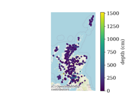
Peat depth measurement locations
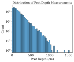
Distribution of peat depths

