Above-ground biomass estimation in Finland
Objective
This subproject evaluates the performance of TESSERA representation maps in above-ground biomass (AGBM) estimation in Finnish forests. Accurate AGBM estimation is essential for assessing the carbon sequestration capacity of forests and tracking changes caused by deforestation and recovery.
Dataset
We use the BioMassters dataset, which contains 11,462 patches representing AGBM in Finnish forests from 2017 to 2021. Ground-truth measurements are obtained with airborne LiDAR.
Each patch consists of 256×256 pixels, with each pixel covering a 10×10 meter area. The dataset is split into 8,689 training patches and 2,773 testing patches.
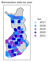
Patch locations by year of data collection

Results
We trained a UNet-based regressor on the TESSERA embeddings to estimate AGBM from satellite imagery. This model was found to outperform a UPerNet trained on the SpectralGPT embeddings [1] – a combination found in the PANGAEA benchmark [2] to outperform other tested foundation models. Furthermore, TESSERA achieved results comparable to Google's AlphaEarth embeddings [3] and to the state-of-the-art bespoke model, the winner of the Biomassters competition [4]. For detailed description of methods and results, see the paper of Zheng et al.: TESSERA: Precomputed FAIR Global Pixel Embeddings for Earth Representation and Analysis, Preprint on ArXiv, July 2025.