Difference between revisions of "Above-ground biomass estimation in Finland"
Jump to navigation
Jump to search
| Line 8: | Line 8: | ||
The dataset is a georeferenced subset of the [https://nascetti-a.github.io/BioMasster/ BioMassters dataset], containing 11,043 patches representing AGBM in Finnish forests from 2017 to 2021. Ground-truth measurements are obtained with airborne LiDAR. | The dataset is a georeferenced subset of the [https://nascetti-a.github.io/BioMasster/ BioMassters dataset], containing 11,043 patches representing AGBM in Finnish forests from 2017 to 2021. Ground-truth measurements are obtained with airborne LiDAR. | ||
| − | |||
| − | |||
Each patch consists of 256×256 pixels, with each pixel covering a 10×10 meter area. The dataset is split into 8,689 training patches and 2,354 testing patches. | Each patch consists of 256×256 pixels, with each pixel covering a 10×10 meter area. The dataset is split into 8,689 training patches and 2,354 testing patches. | ||
| − | |||
| − | |||
| − | |||
| − | <gallery widths=" | + | <div style="text-align: center;"> |
| + | <gallery widths="250" heights="250"> | ||
File:Biomassters_locations.png|Patch locations | File:Biomassters_locations.png|Patch locations | ||
File:Agbm_distributions.png|AGBM distribution | File:Agbm_distributions.png|AGBM distribution | ||
</gallery> | </gallery> | ||
| + | </div> | ||
Revision as of 19:31, 26 May 2025
Objective
This subproject evaluates the performance of Tessera representation maps in above-ground biomass (AGBM) estimation in Finnish forests. Accurate AGBM estimation is essential for assessing the carbon sequestration capacity of forests and tracking changes caused by deforestation and recovery.
Dataset
The dataset is a georeferenced subset of the BioMassters dataset, containing 11,043 patches representing AGBM in Finnish forests from 2017 to 2021. Ground-truth measurements are obtained with airborne LiDAR.
Each patch consists of 256×256 pixels, with each pixel covering a 10×10 meter area. The dataset is split into 8,689 training patches and 2,354 testing patches.
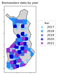
Patch locations
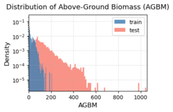
AGBM distribution

